
Please see a list below of 5 local country walks you may enjoy.
Courtesy of Gerry and Gill Brown (2017) – Warbstow Grand Tour
Local Country Walks
Walk 1
Difficulty: Moderate gradients, Distance: 2.7 miles, Time: 1.5 hours, Footwear: Waterproof boots when wet.
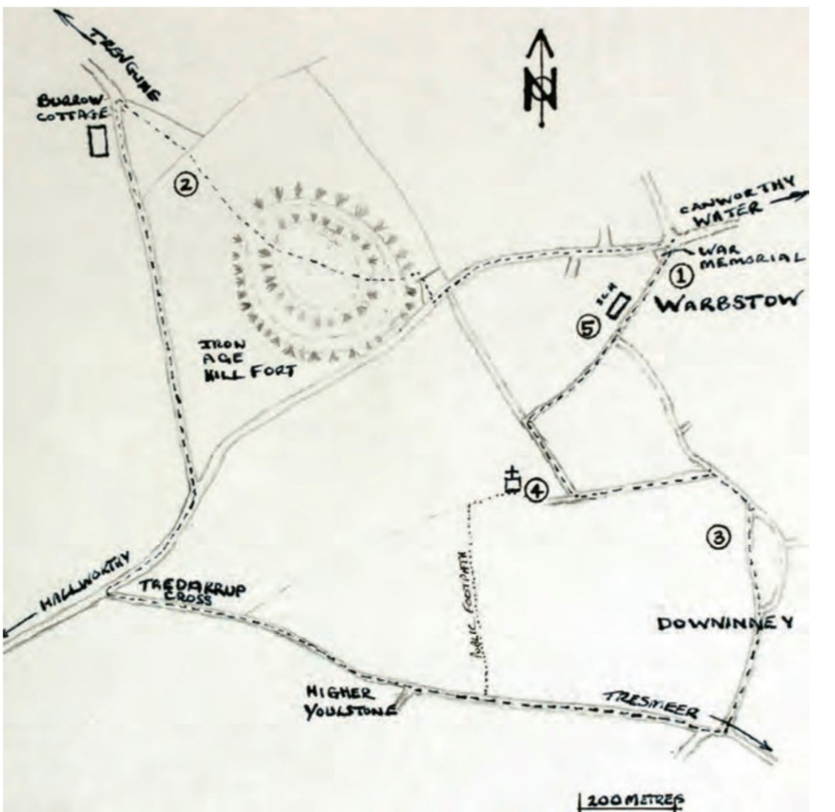
1. We start the walk from Warbstow War Memorial dedicated to the people of Treneglos and Warbstow 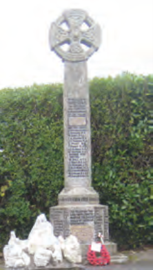 Parish who served their country in the last two world wars. Keep right past the Memorial on the main road, head up the hill on the right hand side towards Warbstow Bury.
On reaching the Bury, pass through the gate and onto the pathway where you will find a notice board giving a brief description of the Mound and its flora and fauna. Warbstow Bury or Barrow is an iron-age earthworks or fortress consisting of double ramparts and outer walls. It is 820ft above sea level and sheep may be grazed there. Continue from the entrance to the Bury across the centre towards a small mound rising on the right at the opposite side. It is worth climbing to the top of this mound to gain a spectacular panoramic view of the countryside around. From here can be seen the
white dishes of GCHQ that stand on the top of the cliffs above Morwenstow. On a clear day the outline of Lundy Island can be seen rising from the sea.
2. Turning right there appears to be a lake in the distance and this is Canworthy Water Solar farm reflecting the sky. Beyond this lie the hills of Dartmoor and a faint outline of Launceston Castle. Continuing on through a gate leaving the Bury, crossing this field and down to the next gate, follow a grass path through a field keeping on the right hand side by the hedge. Passing by some barns and a fence on the left at the bottom of the field exit through a gate onto a lane turn left past Burrow Cottage. Whilst climbing the road, turn and look back and enjoy a view of the coast. At the top of this road, turn sharp right onto the main road and after two hundred metres you will come to Tredarrup Cross where a sign points left towards Tresmeer and Downinney.
Crossing the main road and continuing down the hill towards Downinney, ahead lies Dartmoor and glimpses of surrounding fields and hills through farm gates and hedgerow gaps. On reaching the bottom of the hill you will
come to a crossroad with a sign to Tresmeer and one to Downinney. Bear left towards Downinney passing Lower Town Farm on your right and walkup a short hill.
3. the old village green to the left of which was originally a livestock pound for straying cattle and other 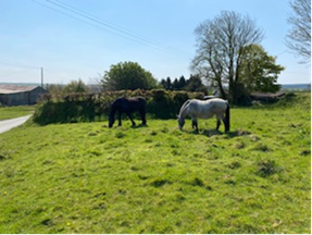 farm animals that would be restored to their owners for a payment of tuppence.
The Parish green itself was once the scene of many activities such as fetes and meetings and it is said that John Wesley preached here on several occasions. At one end of the green is where the original Manor of Downinney stood which is mentioned in the Domesday Book. Continuing ahead with the green on your right, follow the road away from Downinney as it bears left.
Ahead you can see the white houses of Warbstow on the hill. Upon reaching a lane that turns sharp left from the road, continue along this lane until you reach a farm at
the top.
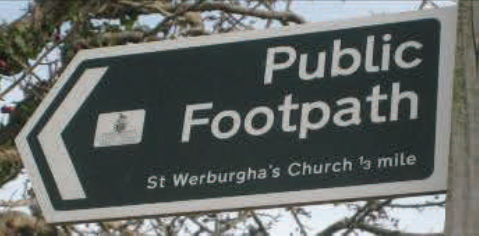
4. Follow the road round to the right where you will pass St Werburgh’s Church at the top of
 the hill. This parish church was built by the Normans and dedicated to the saint, a Saxon woman, who died in the latter part of the 7th century. She was the daughter of Wulfar, King of Mercia. Her presence here is probably due to the settlement of Saxons in this part of Cornwall after they
pushed the Celts further down to the West.
At the bottom of the hill, the road passes over the River Inney and where
it continues beside a long lane into Warbstow, follow the path with the
Inney on your right. In the Spring and Summer the edges of the river are filled with ferns, pink campion and white stitchwort.
5. As you re-enter the village you will pass by the new Community Centre on your left, followed by
 Carnak, a 100 year old house and Warbstow School, built in 1879.
Continue through the village past original old Cornish stone cottages,
namely Rose Cottage on your left and Cobblers Cottage to your right then back up to the War Memorial bringing you to the end of your walk.
—————————————————————————————————————————
Courtesy of Gerry and Gill Brown (2017) – Week St Mary via Penhallam & St. Mary the Virgin Church
 Local Country Walks
Walk 2
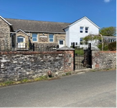
Difficulty: Moderate, Distance: 3.00 miles, Time: 2.5 hours, Footwear: Walking boots or Wellies, can be muddy. There is free parking in front of St Mary`s Post Office.
 1. There is free parking in front of Week St Mary’s
Post Office. Walk away from the Post Office and
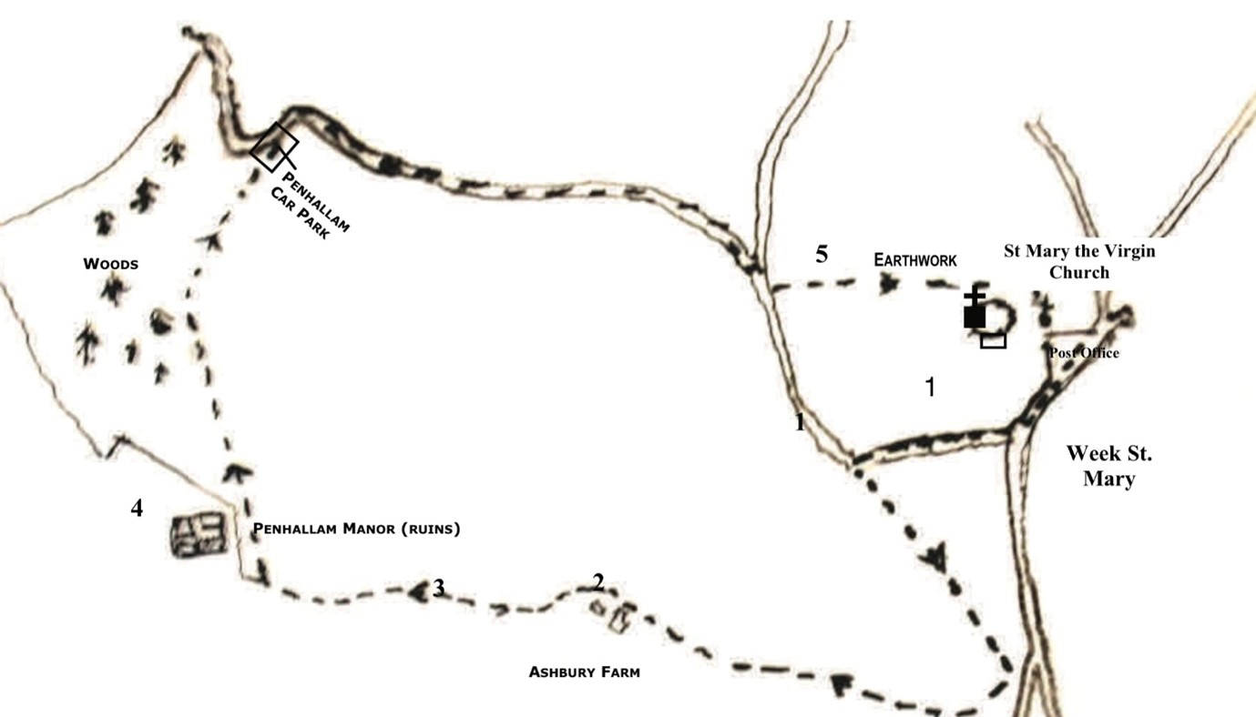
at the sign towards Penhallam turn right, continue
down the lane until on the left you will see, a gate & sign post towards Week Green. Go through the gate and continue along a greenway; atthe end there is another gate and a further 100 metres along is a track leading to the right marked with a footpath sign.
 There are several buildings to the right and left but as you pass the last barn on the left take the right hand fork marked with a way post sign. This will pass through some woods to a stile; as you cross the stile continue on the same path to Ashbury Farm. Keep to the left of the farm track as the right side is also a drain for a spring and therefore muddy. You might see these two fellow wondering what you’re doing on their farm.
Continue straight through the farm and at the last gate turn left. In front of you will be two fields. Take the left hand field but follow the right hand hedge down into the woods; at the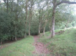
bottom of the hill there are two stiles quite close together and keeping to the right approximately 200 metres on the right is a permissive path sign.
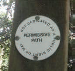
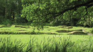
There are two of these that mark the entrance to Penhallam Manor House.
These are the ruins of a 13C Manor house and the foundations have been preserved. More details can be found on the http://www.englishheritage.org.uk/visit/places/penhallam-manor – and it’s free.
Back out over the drawbridge follow the moat round anti-clockwise and you will eventually come to
the main entrance to the site. Follow the main track for approximately half a mile and you will arrive at the official parking area for the site. Follow the lane to the right and continue up a moderately steep hill to a T junction. You’ll need to have had your Weetabix for this climb! Watch out for cars in the lane as it is narrow in places.
At T junction turn towards Week St Mary; opposite is a footpath sign across the
field towards St Mary’s Church which you can see in the distance. Follow the hedge
on the right to a footbridge. Cross the footbridge and stile and approach the earthworks.
 The earthworks are all that remain of a Norman Motte & Bailey Castle that was built to keep the knights safe as they conquered Britain after 1066.
Initially built with earthworks and a timber stockade some became more established and were rebuilt with stone, while others were abandoned once the Norman rule of law was established.
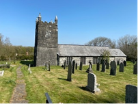
Continue towards the Church and in the centre of the boundary hedge is a stile into St Mary the Virgin’s 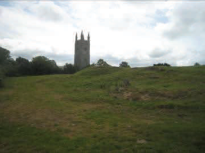 Churchyard, This ancient Church stands on the footings of its Norman predecessor in the original St. Mary’s Wyke. The new church, built in 1643, contains six bells which were hung in 1731 and is finished with battlements and pinnacles which are topped with crosses. Pass through the front gate and the short lane takes you back to the parking area in front of Week St Mary’s Post Office.
Courtesy of Gerry and Gill Brown (2017) – Cambeak headland & the Ludon Valley.
(Start Crackington Haven)
Local Country Walks
Walk 3
Difficulty: Moderate gradients, Steep steps, stick recommended (No hand rails), Distance: 3.25 miles, Time: 3.5 hours, Footwear: Walking boots, can be muddy after rain.

 1. Park in the Burdon Trust Car Park, on the left as you enter Crackington Haven. Walk down the hill and over the bridge.
Turning right onto the South West Coast Path (SWCP). Keep the cliffs to your right as you head out towards Cambeak Headland. Lookout for the striking rock formations.
2. Look out for the bridges crossing the streams and the steep steps. Some are badly worn leaving them slight trip hazards. Continue along the SWCP and enjoy the glimpses of Morwenstow  and Lundy Island on a clear day. As you trek along the path there are several gates with views to Cambeak Headland.
3. At the base of the headland look back across Tremoutha, below, to see why Crackington is called Haven. A trek up to the headland will afford magnificent views across to the coast and further along towards The Strangles beach. Whilst your getting your breath back at the headland take time to also lookout for the Soay sheep that have made the headland home.


The Strangles Beach, popular in the summer has a rocky path down but do check the tides.
4. At the top of cliffs above the beach turn left at the sign post towards the car park approx 200metres. At the lane turn left towards Trevigue Farm. As you pass the farm take the gravel lane down the left side of the farm house and down the steep path to the valley bottom.

5. The Ludon Valley is a broadleaved woodland. Sheltered from the coastal winds it is also a haven of a different sort. Wild flowers in abundance. Follow the valley down to the bridges over the streams and return to Crackington Haven for a well earned Pasty & Chips.
Courtesy of Gerry and Gill Brown (2017) – St Juliot Church to Boscastle
(Start St Juliot, Boscastle)
Local Country Walks
Walk 4
Difficulty: Moderate gradients. Distance: 5.25 miles, Time: 3.3/4 hours, Footwear: Walking boots, Water proof boots when wet. Can be muddy after rain.

1. Park at St Juliots Church. 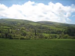 A typical Norman Gothic style church whose restoration was overseen during the Victorian era by one Thomas Hardy the poet and novelist. It was here whilst training to be an architect, that he met his future wife Emma Gifford who was the sister-in-law of the parish priest. They married in 1874 and although it wasn’t the happiest of marriages, when she died in 1912 he placed a memorial plaque to her inside the church. Also in the church, maintained by the Thomas Hardy Society, is a commemoration window of etched glass. Leave by the back of the churchyard over the stone stile down into the fields with views across the Valency river valley. Turn right. Ahead, and slightly angled down across the field you will see a gate with a stile. Over the stile into the next field.

2. Keeping the hedge to your left hand walk the path towards the woods in the distance. As you look back you will get this view of the Church hunkered down into the hillside. Over another stile into the third field you will see to your right a restored cottage with a haha in front.
3. Keeping the cottage to your right you will see in the top right hand corner a small gate leading into the woods. To the right is the gate looking out from the woods. Continue to follow the path around the ruins, just inside the gate, and proceed to follow the path through the woods keeping the river to your left. Continue along the path and as the overhead tree canopy breaks cover there are banks full a  profusion of colourful wild flowers such as stitchwort, primroses, daisies and buttercups, Cornish violets and celandines. Then as you go back under the tree canopy you will be greeted by carpets of bluebells and ramsons (wild garlic). There are several ruins that have to be negotiated en-route down-river hinting at the valley’s extensive industrial past from watermills with leats (now dried up) running along side the path.
 4. At Newmills there is a crossing and further down a bridge on the public footpath leading up from
 Newmills towards Lesnewth that was formerly a donkey track used to transport grain from the farms upriver to the water powered mills. There are several well tended cottages at Newmills some selling small pot plants in aid of the Air Ambulance. Keep on the road for a short distance when you will enter another section of the river walk maintained by the National Trust. Along this section there are also several low lying spots that can get muddy when wet but with a bit of careful course plotting through the trees the worst of the mud can be avoided. This last section of the walk alongside the river brings you out of the woods and into a grassed picnic area with seating and logs to sit on. This is just 300 metres from the main Boscastle car park with toilets and the village beyond. Time for a well earned cup of tea!! The return journey can be completed either by retracing ones steps or following the road back up the hill and turning right at the St Juliot’s church sign. This is easy to negotiate off season but not to be recommended in the high season due to the heavy traffic. But should you decide to risk, it a good view of the Church can be enjoyed from the lane.
—————————————————————————————————————————